![]()
|
|||||||||
|
North America Click here for Canadian Web Games | Click here for USA Web Games | Click here for Mexican Web Games| Click here for Caribbean Web Games
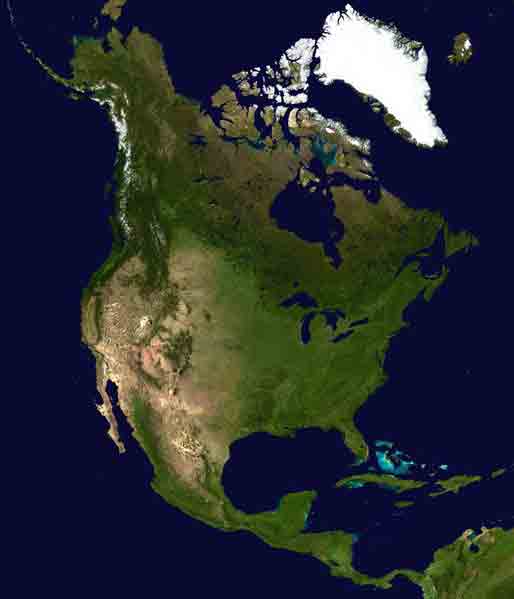
Photo Courtesy of NASA North America is a continent in the northern hemisphere bordered on the north by the Arctic Ocean, on the east by the North Atlantic Ocean, on the south by the Caribbean Sea, and on the west by the North Pacific Ocean. It covers an area of 24,497,994 km² (9,458,728 sq mi), or about 4.8% of the Earth's surface. As of July 2002, its population was estimated at more than 514,600,000. It is the third largest continent in area, after Asia and Africa, and is fourth in population after Asia, Africa, and Europe. Both North and South America are named after Amerigo Vespucci, who was the first European to suggest that the Americas were not the East Indies, but a previously undiscovered (by Europeans) New World. North America occupies the northern portion of the landmass generally referred to as the New World, the Western Hemisphere, the Americas, or simply America. North America's only land connection is to South America at the narrow Isthmus of Panama. (For geopolitical reasons, all of Panama – including the segment east of the Panama Canal in the isthmus – is often considered a part of North America alone.) According to some authorities, North America begins not at the Isthmus of Panama but at the Isthmus of Tehuantepec, with the intervening region called Central America and resting on the Caribbean Plate. Most, however, tend to see Central America as a region of North America, considering it too small to be a continent on its own. Greenland, although a part of North America geographically, is not considered to be part of the continent politically. Plate tectonics recognizes the vast majority of North America as being the surface of the North American Plate. Parts of California and western Mexico are known for being the edge of the Pacific Plate, with the two plates meeting along the San Andreas fault. The continent can be divided into four great regions (each of which contains many sub-regions): the Great Plains stretching from the Gulf of Mexico to the Canadian Arctic; the geologically young, mountainous west, including the Rocky Mountains, the Great Basin, California and Alaska; the raised but relatively flat plateau of the Canadian Shield in the northeast; and the varied eastern region, which includes the Appalachian Mountains, the coastal plain along the Atlantic seaboard, and the Florida peninsula. Mexico, with its long plateaus and cordilleras, falls largely in the western region, although the eastern coastal plain does extend south along the Gulf. The western mountains are split in the middle, into the main range of the Rockies and the coast ranges in California, Oregon, Washington, and British Columbia with the Great Basin – a lower area containing smaller ranges and low-lying deserts – in between. The highest peak is Denali in Alaska. Since 1931, Rugby, North Dakota, has officially been recognized as being at the geographic center of North America. The location is marked by a 4.5 metre (15 foot) field stone obelisk. This article is licensed under the GNU Free Documentation License. It uses material from the Wikipedia article "North America". |