 |
|
 |
|
Golan Heights

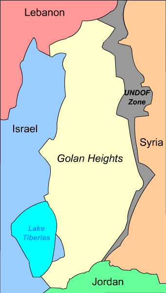
Geographically, the Heights are bordered on the west by a rock escarpment that drops 1700 feet (500 m) to the Sea of Galilee and the Jordan River; on the south by the Yarmouk River; on the north by the international border with Lebanon, and on the east by a largely flat plain, called the Hauran.
The Golan is usually divided into three regions: northern (between Nahals Sa'ar and Gilabon), central (between Nahals Gilabon and Dilayot), and southern (between Nahal Dilayot and the Yarmouk Valley).
Geologically, the Golan Heights are a plateau, and part of a Holocene volcanic field that extends northeast almost to Damascus. The entire area is scattered with inactive cinder cones such as Majdel Shams. Mount Hermon is in the northern Golan Heights but is geologically separate from the volcanic field. Near Hermon is a crater lake called Birkat Ram ("Ram Pool") which is fed by underground springs.
The Israeli army captured the heights and put it under military administration from 1967 until 1981, when the Knesset passed The Golan Heights Law, similar to its 1967 measures concerning Jerusalem. It permitted the imposition of Israeli identity cards in January 1982 on the mainly Druze Syrians who remained there and allowed them to acquire Israeli citizenship, but most objected strongly to the changes and retained their Syrian citizenship instead. This measure is frequently termed an "annexation" but this is very far from clear - the word or equivalent concepts, like "extending sovereignty" are not used in the law itself.
When Prime Minister Menachem Begin was asked in the Knesset why he was risking international criticism for this annexation, he replied "You use the word annexation, but I am not using it." The quasigovernmental Jewish Agency for Israel states that "Although reported as a annexation, it is not: the Golan Heights are not declared to be Israeli territory." On the other hand, the Netanyahu government's Basic Policy Guidelines stated "The government views the Golan Heights as essential to the security of the state and its water resources. Retaining Israel's sovereignty over the Golan will be the basis for an arrangement with Syria." Neither the UN nor any country has recognised the "annexation" and they officially consider the Heights to be Syrian territory under Israeli military occupation. This view was expressed in the unanimous resolution 497 stating that "the Israeli decision to impose its laws, jurisdiction and administration in the occupied Syrian Golan Heights is null and void and without international legal effect." It, like other relevant UN resolutions takes care to not explicitly call it an "annexation", referring at most to Israel's "annexationist policies."
Additionally, Lebanon claims a small portion of the area known as Shebaa Farms on Mount Dov in the area of Mount Hermon. Syria's official position is that the farms are Lebanese territory. UN Security Council Resolution 425 confirmed that as of June 16, 2000, Israel had completely withdrawn its forces from Lebanon, therefore indirectly designating the farms as part of the Golan, and therefore part of Syria.
UNDOF (the United Nations Disengagement Observer Force) was established in 1974 to supervise the implementation of the agreement and maintain the ceasefire with an area of separation. Currently there are more than 1000 U.N peacekeepers there trying to sustain a lasting peace. Syria and Israel still contest the ownership of the Heights but have not used overt military force since 1974. The great strategic value of the Heights both militarily and as a source of water means that a deal is uncertain.
Some Jews and Zionist organizations consider the Golan Heights to be liberated Jewish land; this view has very little support internationally. No other country has accepted the legality of the Israeli communities in the Golan Heights.
Click here to go back to the Middle East Page!
This article is licensed under the GNU Free Documentation License. It uses material from the Wikipedia article "Golan Heights".